


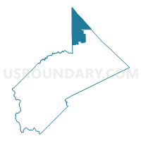
Voting District 10105, Stanislaus County, California
About
Outline

Summary
| Unique Area Identifier | 545118 |
| Name | Voting District 10105 |
| County | Stanislaus County |
| State | California |
| Area (square miles) | 99.26 |
| Land Area (square miles) | 92.65 |
| Water Area (square miles) | 6.61 |
| % of Land Area | 93.35 |
| % of Water Area | 6.65 |
| Latitude of the Internal Point | 37.90788530 |
| Longtitude of the Internal Point | -120.87894430 |
Maps

Graphs
Select a template below for downloading or customizing gragh for Voting District 10105, Stanislaus County, California


Neighbors
Neighoring Voting District (by Name) Neighboring Voting District on the Map
- Voting District 10100, Stanislaus County, CA
- Voting District 10110, Stanislaus County, CA
- Voting District 10120, Stanislaus County, CA
- Voting District 10135, Stanislaus County, CA
- Voting District 41355, San Joaquin County, CA
- Voting District 41356, San Joaquin County, CA
- Voting District 41385, San Joaquin County, CA
- Voting District 41410, San Joaquin County, CA
- Voting District 41420, San Joaquin County, CA
- Voting District 50035, Calaveras County, CA
- Voting District 50040, Calaveras County, CA
Top 10 Neighboring County Subdivision (by Population) Neighboring County Subdivision on the Map
- Oakdale CCD, Stanislaus County, CA (30,054)
- San Andreas CCD, Calaveras County, CA (21,999)
- Escalon CCD, San Joaquin County, CA (13,320)
- Angels City CCD, Calaveras County, CA (12,943)
- Lockeford CCD, San Joaquin County, CA (11,360)
- Linden-Farmington CCD, San Joaquin County, CA (5,423)
Top 10 Neighboring Place (by Population) Neighboring Place on the Map
Top 10 Neighboring Elementary School District (by Population) Neighboring Elementary School District on the Map
- Mark Twain Union Elementary School District, CA (9,310)
- Valley Home Joint Elementary School District, CA (1,641)
- Knights Ferry Elementary School District, CA (608)
Top 10 Neighboring Secondary School District (by Population) Neighboring Secondary School District on the Map
Top 10 Neighboring Unified School District (by Population) Neighboring Unified School District on the Map
- Oakdale Joint Unified School District, CA (28,619)
- Calaveras Unified School District, CA (25,964)
- Escalon Unified School District, CA (14,420)
- Linden Unified School District, CA (11,568)
Top 10 Neighboring State Legislative District Lower Chamber (by Population) Neighboring State Legislative District Lower Chamber on the Map
Top 10 Neighboring State Legislative District Upper Chamber (by Population) Neighboring State Legislative District Upper Chamber on the Map
Top 10 Neighboring 111th Congressional District (by Population) Neighboring 111th Congressional District on the Map
- Congressional District 11, CA (796,753)
- Congressional District 3, CA (783,317)
- Congressional District 19, CA (757,337)
Top 10 Neighboring Census Tract (by Population) Neighboring Census Tract on the Map
- Census Tract 2.10, Calaveras County, CA (9,515)
- Census Tract 49.02, San Joaquin County, CA (6,106)
- Census Tract 2.20, Calaveras County, CA (5,515)
- Census Tract 48, San Joaquin County, CA (5,423)
- Census Tract 1.01, Stanislaus County, CA (4,928)
- Census Tract 47.04, San Joaquin County, CA (4,894)
- Census Tract 1.20, Calaveras County, CA (4,434)
Top 10 Neighboring 5-Digit ZIP Code Tabulation Area (by Population) Neighboring 5-Digit ZIP Code Tabulation Area on the Map
- 95361, CA (31,610)
- 95252, CA (13,460)
- 95320, CA (12,819)
- 95236, CA (4,223)
- 95228, CA (3,976)
- 95230, CA (718)